Bird’s Eye View is a full service GIS shop located in Albuquerque, New Mexico. We serve conservation and community organizations worldwide.

We help people communicate their ideas and data with engaging and powerful maps, offering  everything from basic cartography to web based applications.

Twitter Feed
Tuesday
Jul212015

NMGIC 'Green Chile' Outstanding Service Award

At the most recent New Mexico Geographic Information Council meeting I was honored to be awarded the NMGIC Green Chile Outstanding Service Award. Dr. Ken Boykin, from the New Mexico Cooperative Fish and Wildlife Research Unit, won the Red Chile award. Not sure which is hotter:) 

I'd like to thank NMGIC for this award. I was very surprised and as I told the NMGIC President, "I feel like I'm just getting started!"

Dr. Ken Boykin and Kurt Menke

Tuesday
Jun092015

First User/Educator/Developer QGIS Conference - Nødebo Denmark

I finally have a moment to report back on the first ever international QGIS User/Educator/Developer conference in Nødebo, Denmark. It was certainly one of the best GIS conferences I've been to. It had a very intimate feel. The setting at the Forestry School of the University of Copenhagen (Skovskolen) was beautiful and peaceful. It was located in one of Denmarks largest forests and there were numerous trails and forest gym play areas.

Danish forest (Gribskov) near the conference groundsI had a lot of great conversations, some with old friends, and some with people I've known only from the QGIS-sphere. It was exciting the meet the latter face to face! There were ~150 attendees from 25 countries, and being one of only two Amercans was stimulating and refreshing.  QGIS 2015 Attendee Map

After Jeff McKenna's keynote I presented on the FOSS4G Academy.

OsGeo President Jeff McKenna opening the conferenceThere were some really good talks and workshops over the first two days. One highlight was a fruitfull round table discussion on education, curricula and certification. I'm excited to announce that our FOSS4G Academy material are being adopted by the QGIS project. This is the best chance for this material to survive and grow past 2015. 

My personal conference highlights included: 

  • Matthias Kuhn presenting QField - this will be a mobile version of QGIS
  • Nyall Dawson and Andreas Nuemann showing new advances in rendering and the Print Composer - there are a lot of great tools coming out in the near future
  • Anita Graser showing all the new features of the Time manager - it's becoming a very powerful data visualization tool
  • Tim Sutton leading an open discussion on the future of QGIS. It's not clear when version 3.0 will be released or what upgrading to Qt5 and Python 3 will involve. However, the QGIS development team will give us plenty of lead time before that change happens.
  • The farewell dinner held in a huge tent in the forest. The Danes know how to throw a party!Farewell dinner
  • Meeting people I've known only via the QGIS-sphere including my co-author Luigi Pirelli and conference organizer Lene Fischer!Myself and Luigi Pirelli - Mastering QGIS!
  • Making new Danish friends


Group shot QGIS 2015

Thanks to Lene Fischer and the staff and students at the University of Copenhagen Forestry School for organizing a great conference! Here's hoping there is a follow on educational conference there next summer!

My wife and I posing with Lene Fischer

I didn't stick around for the developer meeting and the hackfest. I instead spent some time sightseeing and relaxing on the north coast of Zealand in a town named Gilleleje.Sunset over the Kattegat


Saturday
May092015

Excited to be Attending the 1st QGIS Conference!

Monday I'm heading to Denmark for the first time to attend the first joint developer | user | educator QGIS conference. In 2003 I attended the first Mapserver Users Meeting and it feels like there are some similarities. That meeting was also held at a Forestry College (St. Paul, MN) and had about 150 people as are exptected in Nødebo. That meeting felt cutting edge and exciting. It was several years before FOSS4G's came into existence. This feels like it might have a similar excitement to it.

First Mapserver Users Meeting (2003)

I'll be one of only two American attending. I am anticipating meeting many of the European QGIS developers and bloggers that I only know from the Twittersphere. This includes one of my co-authors of Mastering QGIS. There will be some great talks and workshops. Before and after my wife and I will be able to tour the Danish countryside. Stay tuned...

Tuesday
Mar312015

Mastering QGIS is Ready for your Bookshelves!

It is with great excitement and pride that I announce our book Mastering QGIS has been published! I co-authored this book with Dr. Richard Smth, Dr. Luigi Pirelli and Dr. John Van Hoesen. It is available as both an eBook and in hard copy from Packt Publishing and Amazon.

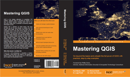
Mastering QGIS Cover

QGIS is the leading alternative to proprietary GIS software. Although QGIS is described as intuitive, it is also, by default, complex. Knowing which tools to use and how to apply them is essential to producing valuable deliverables on time.

Starting with a refresher on QGIS basics, this book will take you all the way through to creating your first custom QGIS plugin. By the end of the book you will understand how to work with all the aspects of QGIS, and will be ready to use it for any type of GIS work.

The introductory section servers as a quick start guide for those with little QGIS experience. It includes directions for installing QGIS on all the major platforms, reviews the layout of QGIS Desktop and Browser, and covers adding data, working with projections, querying tables, creating maps and finding and installing plugins.

From the refresher, you will learn how to create, populate and manage a spatial database and walk through styling GIS data, from creating custom symbols and color ramps, to using blending modes. In the next section, you will discover how to prepare vector and raster data for processing and discover advanced data creation and editing techniques, such as geocoding, georeferencing and topological editing. The last third of the book covers more technical aspects of QGIS, including working with the Processing Toolbox, how to automate workflows with batch processing, and how to create graphical models. Finally, you learn how to create and run Python data processing scripts and write your own QGIS Plugin with pyqgis.

This book is the most thorough tutorial for everyone needing a free and open source desktop GIS.

Saturday
Mar142015

Geo For All Announces Nominations for Global Educator of the Year! 

As a part-time educator it is exciting to be nominated for the Geo For All Global Educator of the Year Award! I've been passionate about promoting FOSS4G for many years and am excited to see it gaining more traction in eductional programs. I was fortunate to be nominated for a course I developed, and have been teaching for the last 6 years, at Central New Mexico Community College. I have also been part of the GeoAcademy team. I developed 3 of the 5 courses and have been teaching them on line through Del Mar College. Our team was nominated for that work as well. As we say everyone can 'Steal this curriculum for Free'! https://foss4geo.wordpress.com/


Saturday
Mar072015

Announcement: Learn the new QGIS 2.8.1!

The GeoAcademy is pleased to announce the launch of their new Introduction to Geospatial Technology Curriculum. The curriculum will be based on the latest version of QGIS, version 2.8.1 Wien which is a long term release (LTR).

The curriculum is a complete package of five GIS courses leading to a Certificate of Proficiency in QGIS from the Del Mar College continuing education program. The five courses will be offered in a limited-enrollment online class format (25 students maximum), taught by leading GIS professional educators (GISP & PhD) who created the course material. I am one of the instructors.

The first course, GST 101—Introduction to Geospatial Technology Using QGIS 2.8.1 will begin April 3, 2015 to be followed each month by a new course through August 2015. Tuition is $25 USD per course, or a total of $125 for all five in the Certificate of Proficiency. The courses include:

  1. GST 101—Introduction to Geospatial Technology Using QGIS 2.8.1 (April 2015)
  2. GST 102—Spatial Analysis Using QGIS 2.8.1 (May 2015)
  3. GST 103—Data Acquisition & Management Using QGIS 2.8.1 (June 2015)
  4. GST 104—Cartography Using QGIS 2.8.1 (July 2015)
  5. GST 105—Remote Sensing Using QGIS 2.8.1 and GRASS 7.0 (August 2015)

Anyone interested in learning more about the offer or enrolling should contact the GeoAcademy director: Phillip Davis at (361) 698-1476 or email:pdavis@delmar.edu